
It's Spring and time for another report from the air about creek conditions and other points of interest.

My good friend and SouthWings pilot Tom Kahlert picked me up in his replica of a vintage Bird Dog surveillance plane for the mission. The Bird Dog is an excellent platform for photography. Two seats are aligned front to back with all windows capable of opening. From his seat in the front, the pilot can see every target I am looking at. With a pilot as experienced as Tom there's very little need for correction.
 |
| Bama Belle |
Leaving Bama Air we flew north along the Black Warrior River through town. First up was the Bama Belle parked at the city pier.
 |
| Cotton Blossom |
Right above the Bama Belle was the newest addition to Tuscaloosa's stern wheel fleet, the Cotton Blossom. William and Fonda Sherrill of Tuscaloosa County purchased the historic showboat the Cotton Blossom in Manderson, La., and traveled the Intracoastal Waterway for 12 days to get to Tuscaloosa. Built in 1928, the Cotton Blossom was the boat featured in the film "Show Boat" in 1951, based on the Broadway musical, which takes place on the Mississippi River. I'll write more on this one later.

Over the years I have seen seen the University of Alabama grow along the river. Many new buildings and landscaping that was not always done using the most protective measures for the river.

This sediment bar has grown exponentially with the University. New people are using newer techniques to contain the run-off with pretty good results but the signs of the past are still visible from the air.

The work on the new entrance to the University is a measure of the new containment. Not much run-off could be seen at all. I returned later with Black Warrior Riverkeeper to check it out from his boat and it looked to be in good shape.
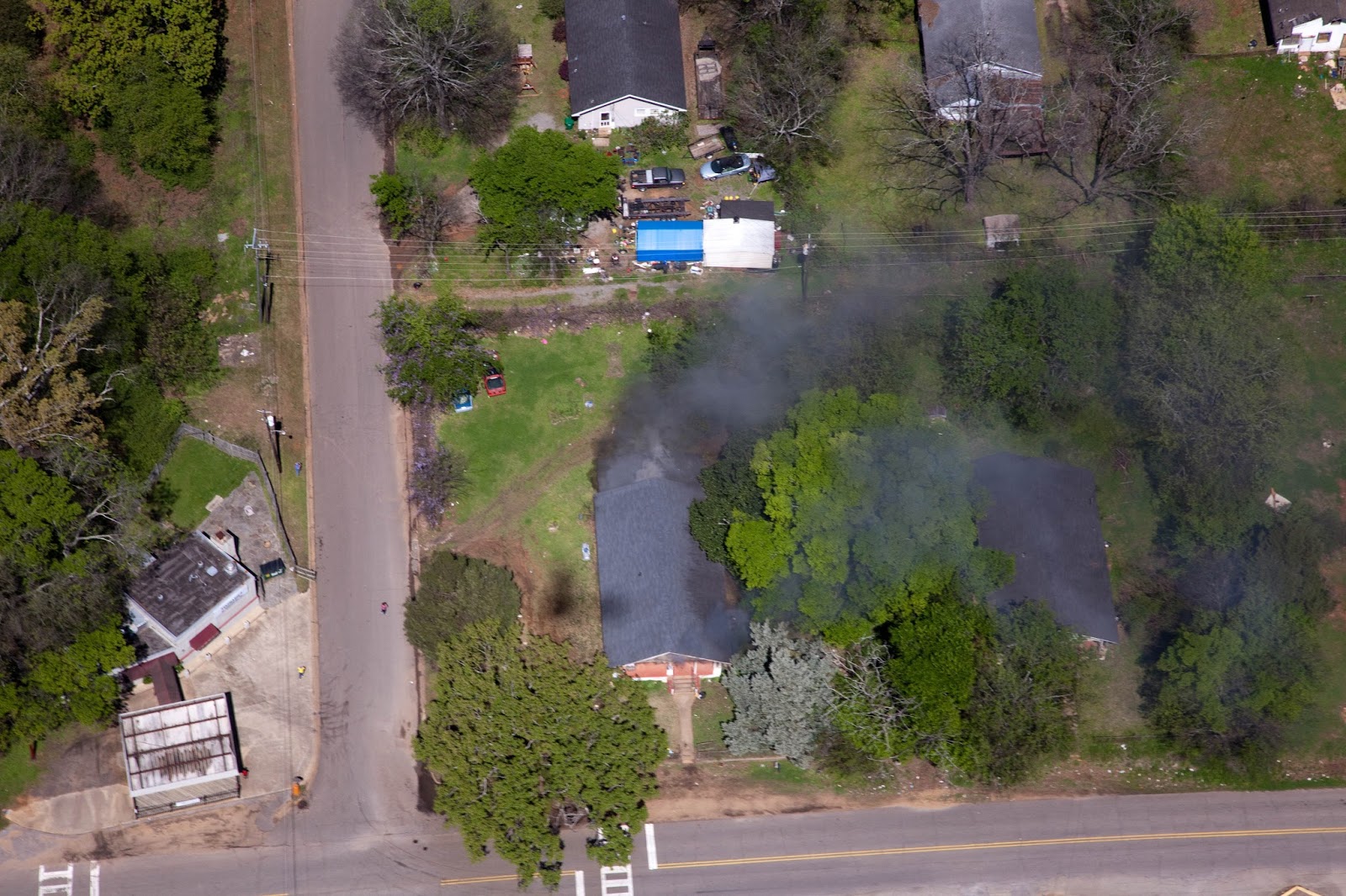
On a heading from town to the mouth of Hurricane Creek I spotted smoke in the vicinity of an unpermitted landfill that has been known to catch fire so we flew over the area. Directly across from Holt High School we found a house on fire.

At first it was just smoking but after a couple of passes we saw a house just beginning to burn. No fire trucks were visible so we called the tower and had them report it. Within minutes Tuscaloosa Fire Dep. showed up and we left to finish the flight. I found out later that no one was hurt.
We were already over Holt so it made sense to shoot over to the Eagle Bluff Landfill or as my dear friend Nancy Callahan refers to it... "Buzzards Roost"

I like to call it Mount Trashkaloosa.
It is, in my opinion the nastiest scar on the horizon. The bright red mounds of dirt covering metric tons of debris with more coming every day. It has been impossible to get the state or even EPA to enforce the rules set in place to protect our community or Hurricane Creek.

Even going to the mailbox is a dangerous adventure for some residents as this photo demonstrates. The pavement is 12 feet from this lady's home and only 15 feet from her living room, kitchen and dining room table. She says the noise and dust are very bad inside her home.
I have witnessed it and agree.
Just up the street is the local cemetery. What I have, and continue see the landfill traffic do to this community should be considered criminal. According to Title 6 of the Clean Water Act dealing with disproportionate impact to communities of poverty, race, or ethnicity is not allowed, however the overwhelming numbers of landfills like this one are in just such communities.

From the air you can see the mud caked street. The side of the road has built up a foot in places from all the mud creating rivulets and rills where it pours off the road heading to Hurricane Creek.
The truck tires pass within 3 feet of family graves. I have witnessed whole funeral processions stopped in total gridlock with trash truck drivers arrogantly gesturing and cursing people who are grieving.
No community should have to endure such treatment.

According to the permit this facility must control litter, cover ALL waste must be completely covered by the close of business on Fri., maintain vegetative cover on all closed slopes, and regular cleaning of facility entrance to control off-site sediment tracking. (ADEM permit #ALR160090 section 4, storm water control measures, paragraph 4.2)
 |
| Landfill from Creek Road 01/04/14 |
The last time this slope was covered by my photo records was in Jan of 2014. Even then it wasn't completely covered and some of the same trash can still be seen sticking out of the slope.
 |
| Landfill from Creek Road 03/12/16 |
This photo taken 03/12/16 shows the trash pile higher but not covered and trash flagging out of the eroded slopes. ADEM inspector Janna McIndoe has repeatedly since early 2014 made comments to the effect that the erosion rills and trash should be covered. This photo was taken on a Sunday indicating a lack of cover violation.

She states on May 14, 2015 "Continue working to correct seeps and repair erosion rills"
The seeps can be seen here with the deep and dark green patches of grass right next to the huge erosion rills! Taken 03/13/16.

This one was taken 12/01/15. Not much has been done to correct anything from what I see since 05/14/15.
It's time for ADEM to start taking enforcement seriously. The new structure of funding whereby ADEM is financed through the permits issued it is unlikely that we will see anything different any time soon. ADEM claims their job is not to enforce the Clean Water Act but to issue permits. Is it any wonder why landfills like this one get away with such chronic non compliance? I could go on for pages about this polluter but I'll save it for another post.
Onward and upward to the mouth of Hurricane Creek. It was somewhat turbid but nowhere as bad as I have seen it in the past. I'm not sure exactly why but I'd like to think the presence of Friends of Hurricane Creek had a lot to do with the decrease over the years.

 Upstream we came upon the WATCO RR bridge over the creek. A vast section of it was blown down during the tornado on Apr 27, 2011.
Scott Bridge Co. did an exceptional job of replacing the bridge while
having "0" upsets or bad discharges into Hurricane Creek. Even today
almost 5 years later the best management practices including check dams,
silt fences and all stone work area can be seen in place. They proved
that good stewardship can also be profitable.
Upstream we came upon the WATCO RR bridge over the creek. A vast section of it was blown down during the tornado on Apr 27, 2011.
Scott Bridge Co. did an exceptional job of replacing the bridge while
having "0" upsets or bad discharges into Hurricane Creek. Even today
almost 5 years later the best management practices including check dams,
silt fences and all stone work area can be seen in place. They proved
that good stewardship can also be profitable.
This is the parking lot at the PARA Hurricane Creek Park

It this case it was made worse by using it for a french drain to channel a spring through the waste to the creek.
Due to planning errors the contractor decided to build this.

 The trench was filled with 24 inches of mine waste. It is approved for aggregate by DOT specs but an ALDOT (Alabama Dep of Transportation) representative told me recently they don't use it anymore due to suspected environmental issues and it doesn't hold up. (( I was recently informed by ALDOT that the pit where this came from is NOT on the approved list of suppliers of aggregate. Comment added 06/22/16)) You can look in the ditches along the edge of Hwy 216 and see where it is crumbling even with no traffic on it. The rock brought in to fill this had coal visible in the loads. I commented to the contractor that it wasn't very stable. He said it was approved and cheap so he was using it anyway.
We went from this on 12/18/15
To this on 03/28/16.


I am going to do a series about this as time goes by but here is a look at where the rock comes from...
This is the Howton Mine, just off Hwy 216.

It also is a source of mine rock that is not much better than waste. The tiny black pile between the rock pile and the active mine is all the coal visible. It looked pretty obvious that more rock was being sold than coal.

Looking straight into the working face you can see the bright orange stain of iron which indicated potential acid mine drainage issues. But look further where the rock is being excavated. That is being sold as aggregate and used for parking lots like the one at Hurricane Creek Park.
TRI was another source of the rock / waste.

Here is it's discharge into a tributary of Hurricane Creek.

Here's the discharge into Hurricane Creek on 02/07/08 and again on 03/28/16
 |
| 02/07/08 |
 |
| 03/28/16 |
It has been bleeding orange as long as it has been here. Once this acidic drainage starts it can almost never be stopped. Lower grades of coal bear more Sulfur than the higher grades but it all contains it in varying degrees. Once it is exposed to water and oxygen it becomes Sulfuric acid and begins to dissolve the rocks around it, releasing heavy metals and other substances toxic to fish and wildlife.
I will be working with several federal agencies as well as Black Warrior Riverkeeper to address this and try to keep this from continuing.

In just a few short months you can see the signatory yellow / orange staining at the Hurricane Creek Park where the french drain discharges over the rocks.

It has become very slick so be careful when walking across it.
Above I mentioned TRI (Tuscaloosa Resources Inc.) They were a source of litigation for us years ago.
 It also had a waiver for rock / mine waste sales but as an addition to that it was allowed to become a slurry pond where water is being discharged from a slurry dredge operating in the old Drummond pit along 216. Due to some bad business decision by Walter Energy they wound up closing the mine that supplied both slurry and water to the dredge so it sits high and dry.
Water from here was pumped into the TRI abandoned pit where it discharges through seeps in the blast fractured terrain and discharges to Weldon Creek, a tributary of Hurricane Creek.
It wasn't all about gloom and doom. The return over the "M" Bend showed Spring was just around the corner and that's always something to behold on Hurricane Creek. Watch for my Spring
2016 floral collection of photos coming soon to a PC near you.


