
The flight started out as many have in the past.
Beautiful weather and little turbulence.
 |
| Lake Tuscaloosa spillway |
Turning East out of the airport we flew over town. I couldn't resist getting a few shots of the city, starting with the Stillman College campus.

A little farther up river we got a clear view of the Crimson Tide, Denny Stadium.

The slight overcast sky was perfect for getting good color. I had a feeling this would be a great day for aerial photography.
TUSCALOOSA RAIL YARD
All of these cars are of the old DOT-111 variety. I ground truthed the photo later and found them all to be old variety.
NUCOR
Following the Black Warrior River we came up on NUCOR Steel. I saw some issues there that will need further investigation by your Black Warrior Riverkeeper. I will report more on that later.
 |
| NUCOR Steel |
 |
| NUCOR slag dump |
Crossing NUCOR, we come to the Eastern Bypass / Eastern Boondoggle.

This pork barrel project has been on the books for what seems like a lifetime. It was very poorly planned with very little in the way of any scientific research as required for such huge and expensive undertaking. The EIS was badly flawed and full of half true information. Friends of Hurricane Creek and West Alabama Sierra Club stood together many years ago and challenged the validity of the surveys. So far our demands for information and responsible planning have fallen on deaf ears. ALDOT and a handfull of developers have convinced some of our elected officials that it will ease traffic. I disagree. It is throttled on the North side to where none of the needed truck traffic will be routed around town as some politicians would have you believe.
The Eastern Boondoggle comes from nowhere and leads to the interstate as a development corridor only. Major developers hold the land at every exit and have plans to line their pockets at the expense of citizens who can't even vote for or against the issue or the politicians who are pushing it.
In 2010 there was an editorial in T'News about apartments planned for the bypass corridor on the north side of the river. Despite the many objections, Northport city planners and council approved the project with the knowledge that Alabama taxpayers wold have to pay millions more for the property after construction. I can't imagine Morrow company giving it up without profit.
Then again this year, the Tuscaloosa City planners and council approved a multi million dollar development right in the middle of the same corridor. On the north side of the river again. 640 homes in the higher price range were approved in the corridor. No one can make me believe that ALDOT can and or will ever have the money to buy out houses in that range. "Estimated at $20 million before the construction. The homes will be built in phases and range in value from $300,000 to $1 million, and the development also features 48 acres of open space, walking trails connecting to the Townes of North River and an area for future commercial development." (Tusc News)

It should be noted here that from this point of termination on Jack Warner Pkway to the interstate the entire corridor is in the Tuscaloosa Police Jurisdiction (PJ) None of the people effected by the bypass are in the city limits but only in the PJ. None of us can vote for or against this nightmare. We have the right to pay taxes and expect nothing in return but disrespect.
Mt. Trashkaloosa
From the Eastern bypass you can look in the direction of Cottondale and the largest bright red scar on the horizon is Mt. Trashkaloosa, AKA Advanced Disposal Landfill "Eagle Bluff" Located right in the middle of a residential area it has become quite a nuisance from health, safety and aesthetics. From the ground it is enormous. Towering well above the treeline it covers the area with dust and wind-blown litter and when raining it fills the streets with a thick coat of slimy mud containing a cocktail of whatever the trucks drive through in the waste stream.

After years of citizen complaints ADEM (Alabama Dep. of Environmental Management) has done very little to hold them accountable. Today I noted litter outside the containment area. Heavily eroded slopes with little or no vegetative cover. Deep erosion gullies on slopes that have been bare for months.


The mouth of Hurricane Creek lies just below the dam and was a bit more turbid than I would like to see. It was pretty though with all of the Red-buds and Crab-apples in bloom.

Just inside the mouth is the old GM&O RR bridge once used to shuttle people and coal to and from Kellerman to Tuscaloosa.
The bridge isn't used any more but due to a "superfund" site at one end and US Army Corps of Engineers on the other it can't be accessed any more. It's a shame because it really is a beautifully built structure.


Holt sewer project
We looked over the new sewer line project in Holt. To my pleasure, there weren't any obvious problems to be seen.


PARA Hurricane Creek Park,
Flying over Hwy 216 I found another pleasant surprise. The new parking area for the PARA Hurricane Creek Park is almost ready for paving. I have been watching this site since they broke ground. It is the first time since ALDOT tore that place up and left in abandoned that the runoff is actually cleaner than the creek itself. Great job of doing it right on the front end and still making money on the back side. Good Job!


 Jim Walter slurry pit
Just North of the BWM strip mine is the Jim Walter slurry pit. The pit is about 1.25 miles long and was several hundred feet deep when they started filling it with toxic coal slurry from underground longwall mining. The coal is cleaned using a flotation method of mixing diesel fuel with several other surfactants and emollients that make the coal float and all of the impurities along with the toxic brew of the slurry compound is pumped to the surface and dumped into unlined abandoned strip pits. None of the ground water around here is safe to drink.

I noticed a dredge in the pit excavating slurry for coal pellatizing. A process where slurry is re-mined using a dredge and useable coal processed into a burnable fuel. It is relieving pressure on the over burdened dam so I will take a wait and see approach to what the discharge is like before I render an opinion.
TRI
Right next door to the slurry pit is Tuscaloosa Resources Inc. This is another sore spot for Hurricane Creek. We have fought them in every court Alabama has to offer and recently won a judgement against them and ADEM for issuing the permit into an impaired stream.ADEM administrative judges have been the only ones who ever ruled against us. (surprised?)

The mine is supposed to be in reclamation but below is their final discharge point. Again this is all that Alabama demands of it's coal industry. It's shameful what is called accountability here.


One more time over Denny Stadium for this really cool shot into the bleachers. I thought we were heading in.

 Bomb Train over Northport


In 2010 there was an editorial in T'News about apartments planned for the bypass corridor on the north side of the river. Despite the many objections, Northport city planners and council approved the project with the knowledge that Alabama taxpayers wold have to pay millions more for the property after construction. I can't imagine Morrow company giving it up without profit.
Then again this year, the Tuscaloosa City planners and council approved a multi million dollar development right in the middle of the same corridor. On the north side of the river again. 640 homes in the higher price range were approved in the corridor. No one can make me believe that ALDOT can and or will ever have the money to buy out houses in that range. "Estimated at $20 million before the construction. The homes will be built in phases and range in value from $300,000 to $1 million, and the development also features 48 acres of open space, walking trails connecting to the Townes of North River and an area for future commercial development." (Tusc News)
It should be noted here that from this point of termination on Jack Warner Pkway to the interstate the entire corridor is in the Tuscaloosa Police Jurisdiction (PJ) None of the people effected by the bypass are in the city limits but only in the PJ. None of us can vote for or against this nightmare. We have the right to pay taxes and expect nothing in return but disrespect.
Mt. Trashkaloosa
 |
| Advanced Disposal Landfill is the red scab in the middle |
After years of citizen complaints ADEM (Alabama Dep. of Environmental Management) has done very little to hold them accountable. Today I noted litter outside the containment area. Heavily eroded slopes with little or no vegetative cover. Deep erosion gullies on slopes that have been bare for months.
Mt. Trashkaloosa is now the highest man-made structure around and is made of trash! Holt Alabama is still in recovery from the massive tornado that hit on April 27, 2011. We are trying to improve our community and bring it back to a vibrant area again. Thing is, who wants to invest in nice homes with this ever growing red scab in our faces?
 |
| Last Tuscaloosa county traffic count showed 1,600 trucks a week, or 320 a day |
People living and dieing along 12th street are constantly insulted and
assaulted by the heavy trucks rolling in and out of the landfill. Coming
out their tires are covered in mud that consists of dirt, Sheetrock,
paint, solvents and adhesives, asphalt, concrete dust, and every
imaginable product found in home and building construction debris. Once that mud dries it becomes airborne dust which is in my opinion very
unhealthy for the community.
I mentioned people dieing. The Chambers Cemetery is right outside of the landfill gate. It stays covered in mud and dust from hundreds of trucks passing within a few feet of the graves daily. They were there long before the landfill and should deserve some degree of respect. Funerals are regularly disrupted and blocked by the trucks. What can we expect from a bunch of out of state garbage collectors?
They recently got an increase in traffic to double the old 320 a day. Now they can expect as many as 640 per day.
 | |
| 26 cars in the funeral procession and about 5 trash trucks were in total gridlock for about 15 minutes. |
I did not invade the families privacy. I was invited there by friends and family members to document the interference dust and noise during their grieving process.
The Holt Lock and dam was flowing pretty strong with 10 gates open a couple of feet at least.
The mouth of Hurricane Creek lies just below the dam and was a bit more turbid than I would like to see. It was pretty though with all of the Red-buds and Crab-apples in bloom.
Just inside the mouth is the old GM&O RR bridge once used to shuttle people and coal to and from Kellerman to Tuscaloosa.
The bridge isn't used any more but due to a "superfund" site at one end and US Army Corps of Engineers on the other it can't be accessed any more. It's a shame because it really is a beautifully built structure.
The wide open green field on the creek bank is the future site of the new Friends of Hurricane Creek campground thanks to our great friend, Doug Woodward. Doug has offered us this site as a take out for canoes and camping area. Many thanks to Dr. Woodward for being there for us.
Holt sewer project
We looked over the new sewer line project in Holt. To my pleasure, there weren't any obvious problems to be seen.
PARA Hurricane Creek Park,
Flying over Hwy 216 I found another pleasant surprise. The new parking area for the PARA Hurricane Creek Park is almost ready for paving. I have been watching this site since they broke ground. It is the first time since ALDOT tore that place up and left in abandoned that the runoff is actually cleaner than the creek itself. Great job of doing it right on the front end and still making money on the back side. Good Job!
I spoke with Gary Minor PARA Director and was told we should have it open by mid May or at the latest end of May. Scores of parking places with 3 trailer parking spaces for canoe trailers. I can't wait!
Black Warrior Minerals strip mine
Back to the ugly stuff we flew over Black Warrior Minerals strip mine. They have been bad neighbors for many years and caused untold damage from breaking dams to consistent discharge of known pollutants.
They are now at the end of this cut and then hopefully will reclaim. It will take generations to heal and will never be as good as it was before. I have never been around a strip mine operator who didn't have the same old tired jargon of "We'll leave it better than we found it"
Below you see the working face on the right and what passes for reclamation in Alabama on the left.
It might be humorous if it wasn't so pitiful.
Jim Walter slurry pitJust North of the BWM strip mine is the Jim Walter slurry pit. The pit is about 1.25 miles long and was several hundred feet deep when they started filling it with toxic coal slurry from underground longwall mining. The coal is cleaned using a flotation method of mixing diesel fuel with several other surfactants and emollients that make the coal float and all of the impurities along with the toxic brew of the slurry compound is pumped to the surface and dumped into unlined abandoned strip pits. None of the ground water around here is safe to drink.
I noticed a dredge in the pit excavating slurry for coal pellatizing. A process where slurry is re-mined using a dredge and useable coal processed into a burnable fuel. It is relieving pressure on the over burdened dam so I will take a wait and see approach to what the discharge is like before I render an opinion.
TRI
Right next door to the slurry pit is Tuscaloosa Resources Inc. This is another sore spot for Hurricane Creek. We have fought them in every court Alabama has to offer and recently won a judgement against them and ADEM for issuing the permit into an impaired stream.ADEM administrative judges have been the only ones who ever ruled against us. (surprised?)
The mine is supposed to be in reclamation but below is their final discharge point. Again this is all that Alabama demands of it's coal industry. It's shameful what is called accountability here.
Mercedes Benz
Leaving the mines we flew over to the Mercedes Plant on I-59. It's
always a pleasure to look around their site. Since the day Mercedes came
into the watershed they have been the best environmental neighbors we
have hands down.
The retention pond out front is one of the best kept beaver ponds around. Instead of killing them Mercedes works with them to clean the water before it leaves the site!
ALDOT on I-59
It was
getting time to head back so we flew along the widening project on
I-59. ALDOT had promised us that they would implement some very new and
innovative best management practices during this process. As we flew
along I was greatly impressed with the work. Large retention ponds were installed properly and plenty of redundant best management practices could be seen.
In the median they have excavated in phases and back filled each
excavation with gravel before installing the drain pipes. I have never
seen a better run road project by ALODT. That doesn't mean I believe
they can build the Eastern (boondogle expressway) bypass with the same
control. we'll see.
One more time over Denny Stadium for this really cool shot into the bleachers. I thought we were heading in.
Bomb Train over Northport
As we approached the airport I happened to catch sight of a Crude oil
train (Bomb trains) on the old bridge over the river. It was parked with
the full weight on the old creosote pole span. It could be seen snaking
it's way from right over the Tuscaloosa Amphitheater all the way across
the river and through the middle of downtown Northport.
After this it really was time to call it a day for the flight. We headed back to the airport for a text book perfect landing and a great feeling of accomplishment. I love these flights.
Leaving the airport I decided to check on the parked train. It's called
ground truthing. Sure enough it was still there and was, in fact a bomb train with 1267 crude oil placards. Sitting perched about people's
houses, businesses, traffic and most of the town of Northport was a unit
train or as I call them, bomb train.
The potential for disaster is lost on most people. I have seen too much of the aftermath from wrecks with bomb trains that I would be terrified to live anywhere close to where they pass. It is much closer than you think. A disaster can occur on good tracks and bridges. This one is far from that. I went around and looked at some of the repairs since there was an article proclaiming a 2.5 million dollar fix recently. To be honest I couldn't see much in the way of improvement. There is still rotten wood, Failing poles, shoddy repairs and bomb trains rolling within a few feet of peoples homes.
 |
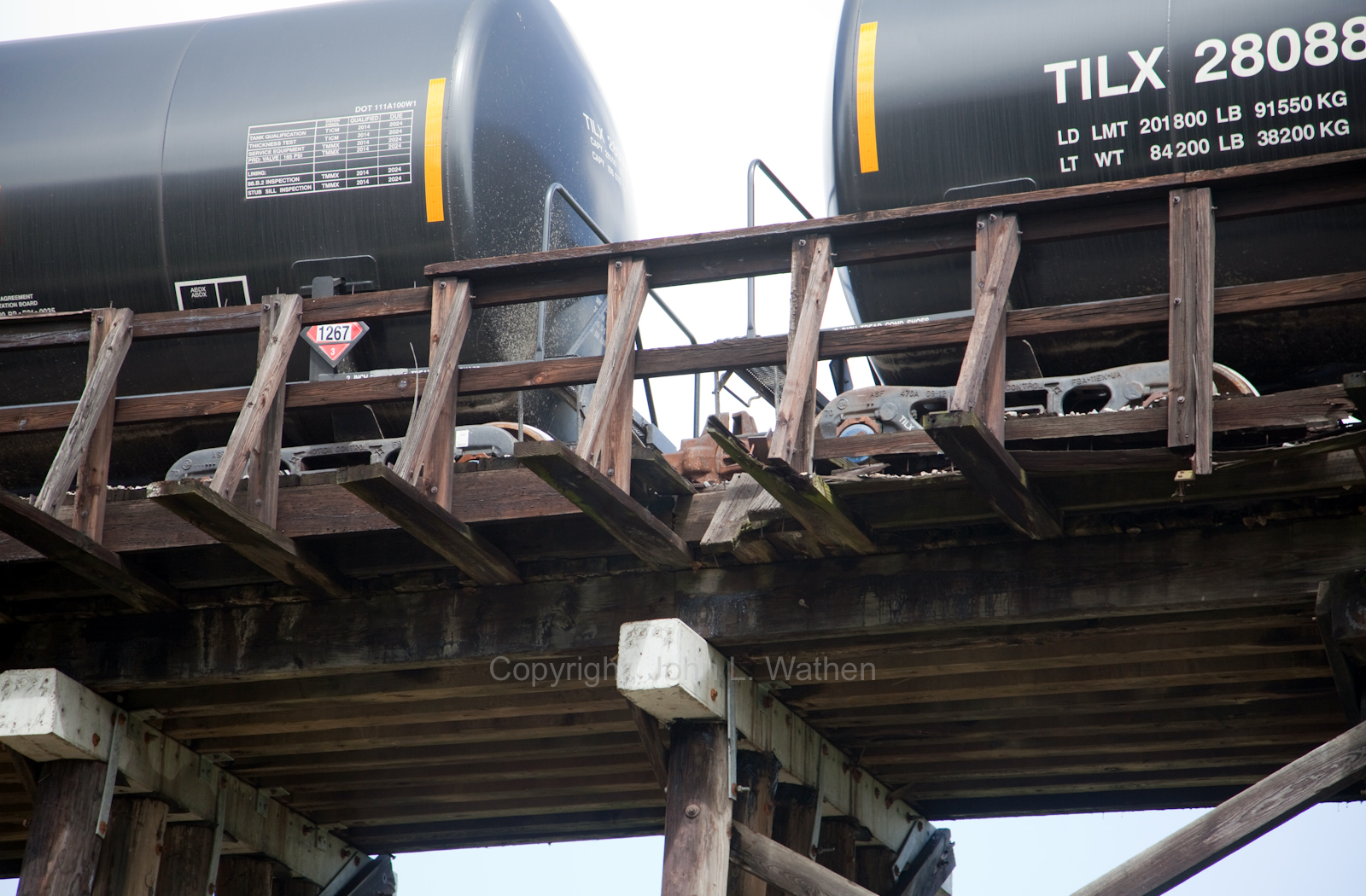 |
| Rotten wood right under the 1267 placard. |
 |
| Makeshift repairs |
I'd like to give a huge shout-out to Thomas Kahlert my pilot for the day.
He is one of the best I have flown with. An ex-Army forward air controller of 40 years experience, he really knew his plane.
Also a big thanks to SouthWings for arranging this and so many flights in the past. It would be impossible to do this work without help and they are without a doubt my angels in the skies!